
Environmental Indexing Design >>>
Environmental Intelligence System Architecture


Objective
To design a comprehensive environmental indexing architecture for Laconic's SADAR platform, enabling advanced environmental intelligence services, including risk informatics for financial and insurance institutions and natural capital monetization (NCM). The system was developed to synthesize environmental data across all domains—atmospheric, terrestrial, and aquatic—and transform it into actionable insights for decision-making.
Role
As the Head of Product for Laconic, I led the design and development of the environmental indexing architecture. My responsibilities included:
Creating a system capable of processing diverse data streams from remote sensing, drones, AUVs, ASVs, buoys, survey teams, and ground sensors.
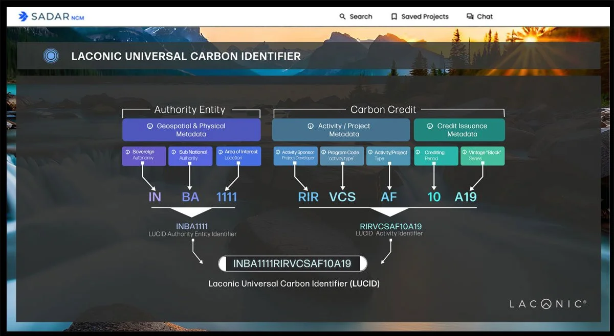
Developing the coding architecture based on ISO standards, NOAA environmental characteristics, HEX3 geospatial mappings, and other authoritative sources.
Collaborating with internal teams to ensure scalability, adaptability, and alignment with Laconic’s flagship products: Natural Capital Monetization (NCM) and risk informatics solutions for finance and insurance sectors.
Leveraging my reconnaissance Marine Corps background to integrate intelligence collection principles into the system’s design.
Approach
Environmental Indexing Architecture Design:
Designed a system to process structured, unstructured, and semi-structured data streams into a unified, actionable format.
Integrated data from a wide range of sources, including remote sensing platforms, aerial survey drones, autonomous vehicles (AUVs/ASVs), buoys, and terrestrial sensors.
ISO-Compliant Standards:
Structured the architecture around ISO environmental data standards, NOAA environmental characteristics, and HEX3 geospatial mapping frameworks.
Incorporated global best practices to ensure accuracy, compatibility, and reliability.
Use-Case Development:
Finance Risk Informatics: Enabled lenders to assess drought risks for agricultural projects using historical weather data and predictive analytics, reducing lending risk exposure.
Insurance Risk Analysis: Provided insurers with tools to identify high-risk coastal areas for real estate development and detect weather-related fraud in claims processing.
Natural Capital Monetization (NCM): Captured high-quality environmental data to support carbon credit validation and measurement, reporting, and verification (MRV).
Digital Twin Integration:
Utilized all-domain awareness capabilities to develop digital twins of monitored environments within SADAR.
Visualized atmospheric, terrestrial, and aquatic data for real-time decision-making and predictive analytics.
Cross-Functional Collaboration:
Worked closely with engineering, product development, and executive teams to align the system’s capabilities with business objectives.
Presented the completed design to internal stakeholders, receiving recognition from the CEO for achieving a design valued at $5 million.
Outcome
Advanced System Capability: Delivered a robust environmental indexing architecture that became the backbone of Laconic’s environmental intelligence services.
Scalable Applications: Enabled a range of use cases, from financial risk assessment and insurance analytics to carbon credit validation and environmental monitoring.
Cost-Effective Innovation: Developed an in-house solution valued at $5 million, providing significant cost savings and operational advantages.
Global Impact: Supported partnerships and contracts across multiple regions by offering cutting-edge environmental intelligence tools to governments, financial institutions, and corporations.
Operational Excellence: Transformed raw environmental data into actionable insights, empowering users to make informed decisions about risk, sustainability, and investment opportunities.
Key Metrics and Features
Data Processing: Integrated structured, unstructured, and semi-structured data streams.
Environmental Domains: Captured and analyzed atmospheric, terrestrial, and aquatic data.
Technology Integration: Utilized remote sensing, drones, AUVs, ASVs, buoys, and ground sensors to achieve all-domain awareness.
Framework Compliance: Built using ISO standards, NOAA characteristics, and HEX3 geospatial mappings for global interoperability.
Actionable Insights: Delivered predictive analytics for finance, insurance, and sustainability initiatives.
Key Takeaways
This project highlighted my ability to:
Design complex systems that synthesize and analyze data across diverse domains.
Translate operational requirements into scalable technological solutions.
Leverage military reconnaissance expertise to create innovative environmental intelligence capabilities.
Drive cost-effective innovation with a design recognized as a $5 million value proposition by Laconic's leadership.
The environmental indexing design set a new standard for actionable environmental intelligence, showcasing the potential of integrating technology, data, and strategy to address global challenges in finance, sustainability, and risk management.